After stuffing myself with dim sums and noodles in Tsim Sha Tsui back in 2019, I finally took the courage to tackle a few sections of the famous 50-km Hong Kong Trail—all by myself. Back then, there were limited resources online. So to pay my experience forward, I've put together this hiking guide series of the 50-km Hong Kong Trail packed with essential details such as hiking sections, maps, trail overview, and logistics!
Disclaimer: Some information in this post was sourced from other blogs, and I've properly credited them for their input. A heartfelt thanks to them!
What's the 50-km Hong Kong Trail?
According to Wikipedia, the Hong Kong Trail is a long-distance footpath from Victoria Peak to Big Wave Bay on Hong Kong Island. It is a 50-kilometer walking route that passes through the five country parks on Hong Kong Island.
Hong Kong Trail Hiking Sections:
The 50-km Hong Kong Trail is divided into 8 stages/sections as below:
| Section Number | Route | Distance Post Numbers | Actual Time Taken |
| Section 1 | The Peak to Pok Fu Lam Reservoir Road | #1 - #14 | 2 hours |
| Section 2 | Pok Fu Lam Reservoir Road to Peel Rise | #15 - #25 | 1 hour and 30 minutes |
| Section 3 | Peel Rise to Wan Chai Gap Road | #26 - #37 | 1 hour and 15 minutes |
| Section 4 | Wan Chai Gap Road to Won Nai Chung Road | #38 - #50 | 2 hours and 15 minutes |
| Section 5 | Won Nai Chung Road to Tai Fung Au/Mount Parker Road | #51 - #59 | 1 hour and 30 minutes |
| Section 6 | Tai Fung Au/Mount Parker Road – Tai Tam Road | #60 - #68 | 1 hour and 30 minutes |
| Section 7 | Tai Tam Road – To Tei Wan | #69 - #84 | Not yet done |
| Section 8 | To Tei Wan – Big Wave Bay | #85 - #100 | Not yet done |
Technically, among the other long-distance trails in Hong Kong, the Hong Kong Trail is the shortest. The other long-distance trails are:
- Lantau Trail (70 kilometers)
- Wilson Trail (78 kilometers)
- MacLehose Trail (100 kilometers)
Despite being the shortest trail (50 km only), I split the trail into two days since it was my first time in Hong Kong and on the trail itself. Instead of rushing it like a trail runner, I ensured that I had enough time to enjoy the trail. I've also included extra time for errors like getting lost, which eventually happened!
Hong Kong Trail Overview:
Before diving into each hiking guide, let me give you an overview of some key factors that can make or break, your hiking experience.
1. Maps
Every hike and outdoor activity should always be backed by a reliable map. Before my hike, I saved tons of map screenshots from various sources (which, unfortunately, I can't seem to find anymore) to help me guide my way.
To my surprise, I didn’t even need them! Each hiking section has a large and detailed map of the trail and its nearby surroundings at its starting point. It shows you everything you need—distance markers, emergency hotlines, toilets, transportation options (taxi, bus, parking), and even picnic spots!
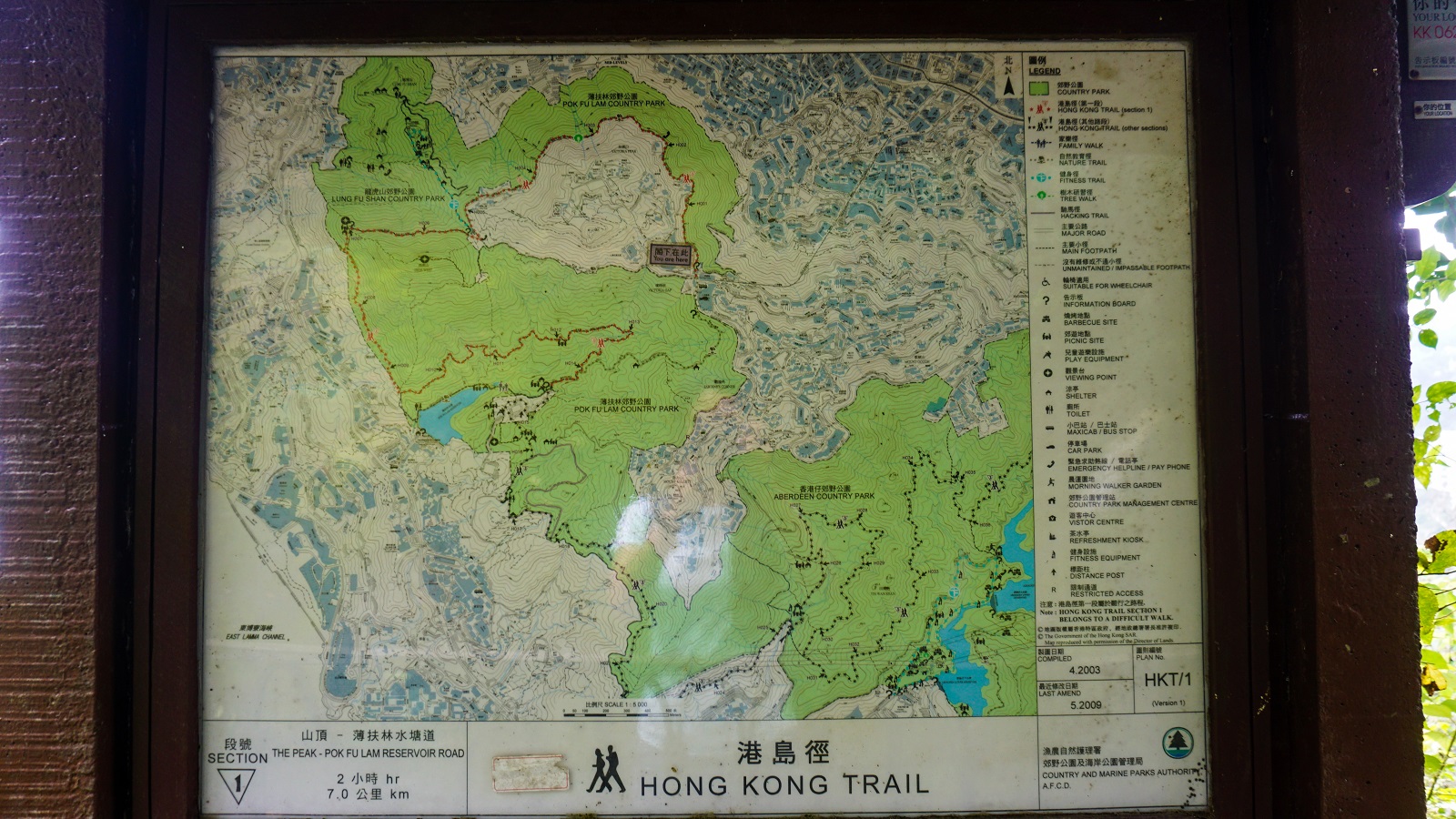
Tip: Take a photo of the map before starting your hike, and make sure you know how to read a basic trail map like this. It’ll come in handy!
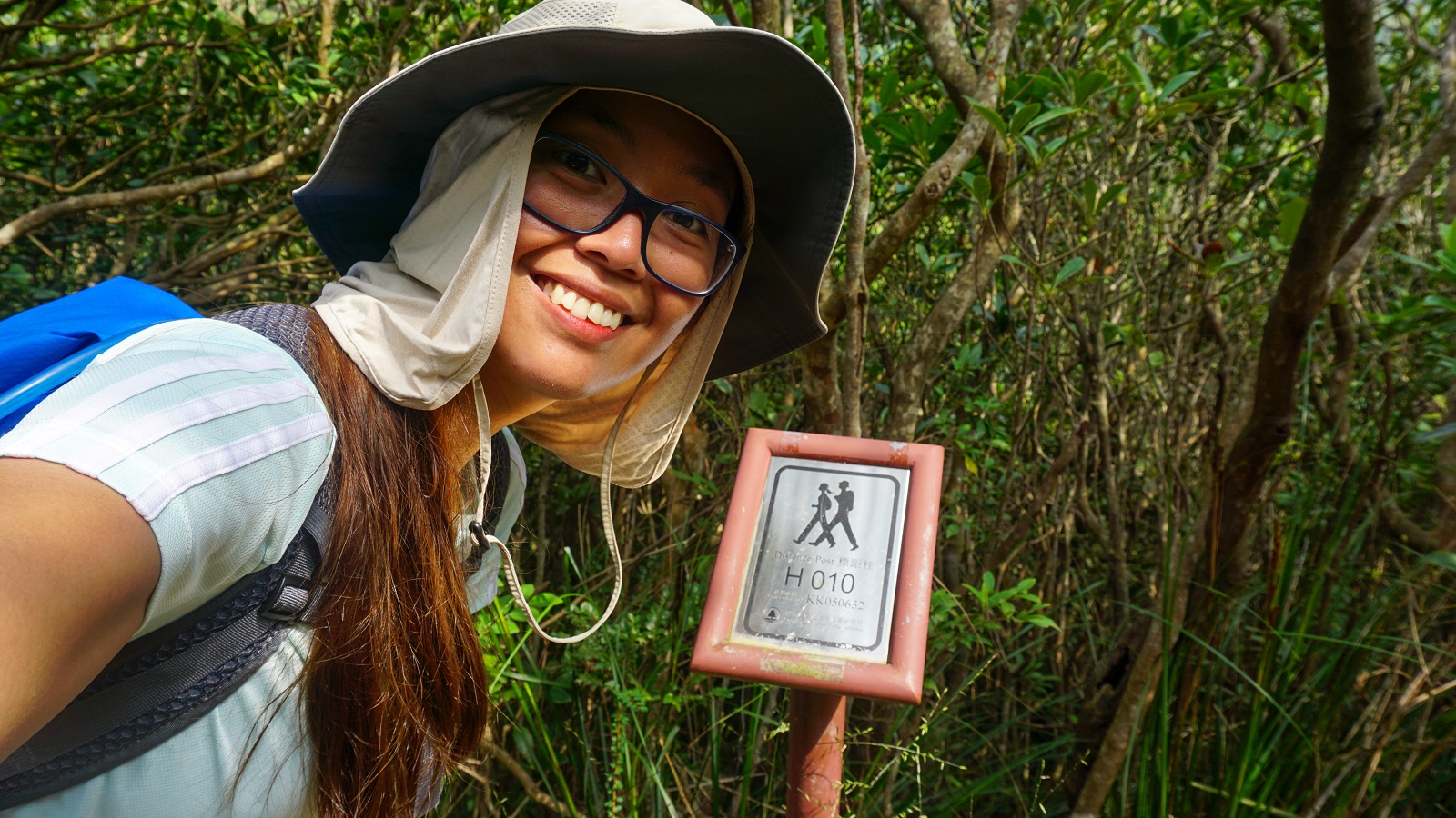
2. Distance Posts
Throughout my hiking guides of the Hong Kong Trail, I kept mentioning the distance posts and you must be wondering what are they. Distance posts are the short metal posts scattered throughout the trail with information such as Distance Post Number (H001 is the first distance post) and Grid Reference (something like a coordinate).
A distance post represents an actual coordinate and is easier to use (and share) during an emergency.
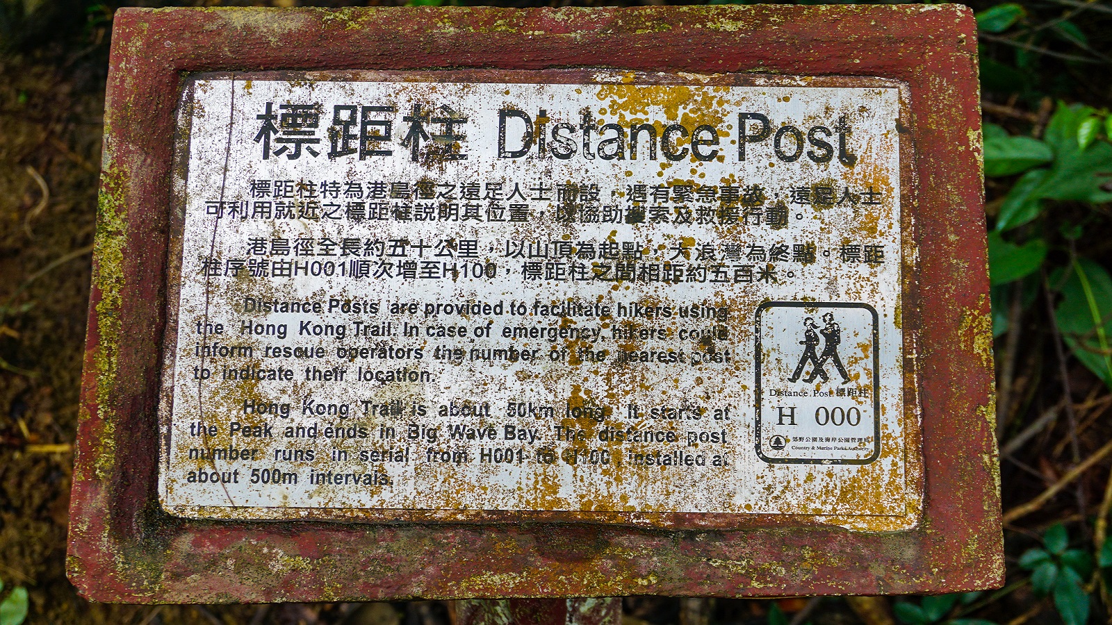
Distance posts are placed every 500-meter interval between the trails to ensure that you are still on the right path.
3. Water Access
As read online from fellow hikers who did this trail, there are sections where you can buy food and drinks. However, I didn’t come across any of them. On a side note, there are natural streams along the way. I drank from one of them when I ran out of water and I’m pretty fine until now. But if you're sensitive to that kind of situation, make sure to bring enough water.
4. Camp Sites
Unfortunately, camping is NOT allowed at any point of the trail. There were some signposts about it so if you're planning to camp, this is not the place.
5. Public Transportation
If you’re like me who's relying on taking public transportation, you’re on the right track! Most of the trails are accessible by public transportation. Other trails have some challenges in the sense that you will have to walk some more (after taking public transportation) before reaching the trail.
In each hiking guide, I have shared instructions on how to reach the trail and how to get out of it. While the information shared was all based on my experience back in 2019, kindly take note that some of it may not be accurate anymore. However, I will try my best to keep updating it to the best of my ability.
Hiking Guide of Hong Kong Trail:
Finally, let's get down to business. This hiking guide series breaks down each section of the Hong Kong Trail, with separate links below for easy navigation. The sections are listed in order from Section 1 onwards (West to East).
And here's the thing—you can hike any trail in no particular order! It's totally up to you. Click on a section below to jump straight to a particular section and start exploring!
- The Peak to Pok Fu Lam Reservoir Road
- Pok Fu Lam Reservoir Road to Peel Rise
- Peel Rise to Wan Chai Gap Road
- Wan Chai Gap Road to Won Nai Chung Road
- Won Nai Chung Road to Tai Fung Au/Mount Parker Road
- Tai Fung Au/Mount Parker Road to Tai Tam Road
That's all for today and I'm closing this with my reminder:
Whatever decision you make, always remember to prepare beforehand, stay safe, and last but not least, enjoy the outdoors! #happyhiking!
With lots of love,
PINAYHAKAWATI 💗
AND AS A GENTLE OUTDOOR ETHICS REMINDER:
LEAVE NO TRACE!